
Base data without the scavenger hunt
KlauPPK finds the public CORS stations around your flight, downloads the observations that cover your mission window and uses them for PPK processing. No provider portals, no time-window arithmetic, no merging files.
3,000+
Public CORS stations
75
Countries
1,300+
Stations with 1-second data
9
Networks, public and subscription
From flight to corrections in four steps
Import your mission. KlauPPK reads the flight time and position from your aircraft's observation files. That is all it needs to search.
See the stations that fit. Nearby CORS stations are listed by distance from the flight, with sampling rate, network and data availability for your mission window.
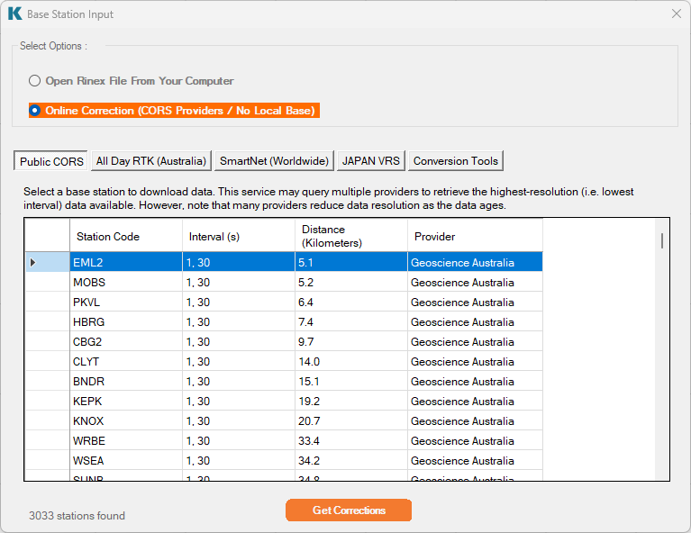
Download exactly what covers the flight. KlauPPK works out the files it needs across each provider's 15-minute, hourly or daily products, downloads them, decompresses them and joins them into one continuous base record for the processing period.
Process. The station's published coordinate, antenna model and antenna height are applied, the data is validated and the flight is processed. Review the solution and export.
What KlauPPK does for you
Stations by distance. Ranked from the flight centre so the shortest baseline is always on top. Distance, sampling rate and the data actually available for your time window are shown before you commit.
Highest rate available. Where a station publishes 1-second data KlauPPK takes it. Otherwise it falls back to 5, 15 or 30-second data and tells you which it used. Over 1,300 stations in the catalogue carry 1 Hz data.
Best product for each station. Providers publish the same station as 15-minute high-rate, hourly and daily files with different retention periods. KlauPPK ranks the products and fetches the best one that still covers your flight.
Only the data you need. The mission window decides which files are downloaded. A 20-minute flight does not pull a full day of observations.
Automatic download and use. Observation and navigation files are fetched, placed and referenced in the project without a file dialog.
Compressed data handled. Hatanaka-compressed RINEX, gzip and zip archives are unpacked automatically. RINEX 2, 3 and 4 are read.
Navigation data included. Broadcast ephemeris is sourced for the same period from the provider or from the global IGS archive, so you never hunt for a nav file.
Validated before processing. Each file is checked for the mission window, sampling rate and observation content. Gaps or unusable data are flagged rather than silently processed.
Surveyed coordinates, not header guesses. For more than 2,200 stations KlauPPK carries the published surveyed coordinate (Geoscience Australia Regulation 13 and NGS CORS positions) and anchors the solution to it instead of the approximate position written in the RINEX header.
Antenna model and height applied. Station site logs supply the antenna type, radome and marker-to-ARP height in effect on the day you flew. A RINEX header does not carry this reliably. A site log does.
Datum known up front. Stations carry their reference frame (GDA2020, NAD83(2011), NZGD2000, ITRF2014) so the transformation to your project datum is set correctly without a lookup.
Your own base still works. Import RINEX from your own receiver and run the same workflow when network coverage or data quality is not suitable.
Supported networks
Public networks
Geoscience Australia. Australia, national and state CORS archive, 700+ stations, 1-second and 30-second data, GDA2020, Regulation 13 surveyed coordinates and site logs.
NOAA NGS CORS. United States, Canada, Mexico, Caribbean and Pacific, 1,600+ stations, 1-second to 30-second data, NAD83(2011), NGS published coordinates and site logs.
GeoNet. New Zealand, 200 stations, 1-second and 30-second data, NZGD2000.
EUREF Permanent Network. Europe, 300+ stations across 30+ countries, 1-second and 30-second data.
IGS (BKG data centre). Global, 30-second data. Fills gaps where no national network exists.
IBGE RBMC. Brazil, 80 stations, 15-second data.
SIRGAS. Latin America, 15-second to 30-second data.
Subscription networks
KlauPPK also connects to subscription CORS services. Enter your credentials once and their stations appear alongside the public ones, searched and downloaded the same way.
AllDayRTK. Australia.
SmartNet. Hexagon, Australia and international.
FAQ
Does KlauPPK work without a base station? Yes, where a public or subscription CORS station is within usable range of the flight. KlauPPK searches the catalogue from your mission's time and location and downloads the data. If no suitable station exists you can use your own base receiver.
How far from a CORS station can I fly? Results degrade with baseline length. Many users work comfortably within 30 km. Longer baselines can still process but with reduced accuracy. KlauPPK shows the distance for each candidate station so you can decide.
Which sampling rate do I need? For drone PPK, 1-second base data gives the best result. KlauPPK takes the highest rate the station offers and interpolates where only 5, 15 or 30-second data exists.
Do I need an account with the CORS provider? Not for public networks. Geoscience Australia, NOAA, GeoNet, EUREF, IGS and IBGE are open data. AllDayRTK and SmartNet need your own subscription credentials.
Can I use my own base receiver instead? Yes. Import its RINEX and continue through the same workflow.

Process your next flight with KlauPPK
Start a 14 day, full-function trial and test KlauPPK with your own project data. No credit card required.